
Content block block-countyoc-docaccessscript

Body
Alert: replacereplace
Select a language:
Orange County Government Logo -- OC Home
Facebook Created with Sketch. Twitter Created with Sketch. Instagram Youtube Created with Sketch.
OC Infrastructure Programs California Logo -- Home
  • OCPW
    • About
    • History
    • Organization Chart
    • Department Highlights and Accomplishments
    • OC Public Works Standard Plans
    • Procurement Services
    • Capital Improvement Program
    • Orange County Civic Center Authority
  • Service Areas
    • OC Construction
    • OC Development Services
    • OC Environmental Resources
    • OC Facilities Design & Construction Management
    • OC Infrastructure Programs
    • OC Operations & Maintenance
  • How Do I?
    • Report
      • Graffiti
      • General Service Requests and Complaints
      • Potholes
      • Property Violations
      • Traffic Concerns
      • Water Pollution
      • Weed Abatement
    • Obtain
      • Inspection Services
      • Land Records
      • Lot Line Adjustments
      • Permits
      • Public Records Request
      • Rainfall Data
    • View
      • Community Plans
      • Corner Record Form
      • Crop Reports
      • Land Records
      • OC Storm Center
      • OC Traffic Committee
      • Public Meeting Agendas
      • Standard Plans
      • Sign Posting Policy
      • Best Management Practices (OC Watersheds)
      • Drainage Area Management Plan
      • Water Quality Management Plan
    • Find
      • 7-Year Capital Improvement Program
      • Building Codes and Ordinances
      • Certified Farmers Markets
      • Development Fees
      • Digital Submission Quick Reference Guide
      • Geodetic Control/OCRTN
      • GIS Open Data
      • OC Civic Center Parking
      • Project Maps
      • Residential Projects
      • Standard Certificates
    • Learn About
      • Adopt-a-Channel
      • Apprenticeship Program
      • Disposing Hazardous Materials
      • Compliance
      • Fire and Emergency Information
      • Flood Insurance
      • Flood Protection
      • Integrated Pest Management
      • Job Opportunities
      • Ocean and Bay Closures
      • Open Bids
  • News
    • Calendar
  • myOCeServices
    • Service Requests and Complaints
    • Apply for...
    • Research Map
    • Account
    • Make Payments
    • Information
  • Contact
    • OC Public Works HQ
    • OC Construction
    • OC Development Services
    • OC Environmental Resources
    • OC Infrastructure Programs
    • OC Facilities Design & Construction Management
    • OC Operations & Maintenance
Search

Breadcrumb

  1. Home
  2. Service Areas
  3. OC Infrastructure Programs
  4. + Santa Ana River Project
banner short ocip
OC Infrastructure Programs

  • + Projects and Studies
    • "OC on the Move" Active Transportation Plan (ATP) 
    • Americans with Disabilities Act (ADA) Transition Plan
    • County of Orange Local Road Safety Plan (LRSP)
    • Brea Boulevard Corridor Improvement Project
    • Canyon Bridges Replacement Project
    • East Garden Grove-Wintersburg Channel Project
    • OC Loop Bikeway Segments O,P,Q
    • Huntington Beach Channel / Talbert Channel Sheet Pile Repair Project
    • Laguna Canyon Channel Replacement Project
    • San Juan Creek Flood Risk Management Feasibility Study
    • Santa Ana Gardens Bikeway Extension Project
    • Santa Ana-Delhi Channel Improvement Project
    • Santa Ana Ave. & University Dr. | Roadway Improvements & Perez Park
    • Santa Clara and Prospect Avenue Drainage Improvements and Sidewalk Gap Closure
    • Santiago Canyon Road Safety Improvements Project
    • Trabuco Canyon Road Bridge Replacement Project
    • Yorba Street Drainage & Roadway Improvements
    • Westminster Watershed Feasibility Study
  • + Santa Ana River Project
    • Lower SAR
    • Santiago Creek
    • Seven Oaks Dam
    • Prado Dam
    • Local Cooperation Agreement
    • Santa Ana River Flood Protection Agency (SARFPA)
    • Project Cost and Schedule
    • Santa Ana River Canyon Habitat Area
  • Hydrology
  • + Flood Control Project Process
    • City Engineers Flood Control Advisory Committee (CEFCAC)
    • CEFCAC Funding Criteria
    • CEFCAC Procedure
    • Project Plan
  • Water Quality Projects
  • + Flood Protection
    • Be Flood Ready! Brochure
    • Flood Fighting
    • Emergency Info
    • Weather and Flood Watch
    • Flood Protection Information
    • Floodplain Management
    • Floodplain Management Plan
  • + OC Road Fee Programs
    • Active Programs
    • Inactive Programs
    • Programs by Location
  • + Traffic Engineering
    • OC Traffic Committee
  • + Documents & Maps
    • Reference Materials
    • Standard Plans & Specifications
    • Drawings & Maps
    • Online Manuals
  • FAQs
  • Glossary of Terms
  • + Projects and Studies
    • "OC on the Move" Active Transportation Plan (ATP) 
    • Americans with Disabilities Act (ADA) Transition Plan
    • County of Orange Local Road Safety Plan (LRSP)
    • Brea Boulevard Corridor Improvement Project
    • Canyon Bridges Replacement Project
    • East Garden Grove-Wintersburg Channel Project
    • OC Loop Bikeway Segments O,P,Q
    • Huntington Beach Channel / Talbert Channel Sheet Pile Repair Project
    • Laguna Canyon Channel Replacement Project
    • San Juan Creek Flood Risk Management Feasibility Study
    • Santa Ana Gardens Bikeway Extension Project
    • Santa Ana-Delhi Channel Improvement Project
    • Santa Ana Ave. & University Dr. | Roadway Improvements & Perez Park
    • Santa Clara and Prospect Avenue Drainage Improvements and Sidewalk Gap Closure
    • Santiago Canyon Road Safety Improvements Project
    • Trabuco Canyon Road Bridge Replacement Project
    • Yorba Street Drainage & Roadway Improvements
    • Westminster Watershed Feasibility Study
  • + Santa Ana River Project
    • Lower SAR
    • Santiago Creek
    • Seven Oaks Dam
    • Prado Dam
    • Local Cooperation Agreement
    • Santa Ana River Flood Protection Agency (SARFPA)
    • Project Cost and Schedule
    • Santa Ana River Canyon Habitat Area
  • Hydrology
  • + Flood Control Project Process
    • City Engineers Flood Control Advisory Committee (CEFCAC)
    • CEFCAC Funding Criteria
    • CEFCAC Procedure
    • Project Plan
  • Water Quality Projects
  • + Flood Protection
    • Be Flood Ready! Brochure
    • Flood Fighting
    • Emergency Info
    • Weather and Flood Watch
    • Flood Protection Information
    • Floodplain Management
    • Floodplain Management Plan
  • + OC Road Fee Programs
    • Active Programs
    • Inactive Programs
    • Programs by Location
  • + Traffic Engineering
    • OC Traffic Committee
  • + Documents & Maps
    • Reference Materials
    • Standard Plans & Specifications
    • Drawings & Maps
    • Online Manuals
  • FAQs
  • Glossary of Terms

Santa Ana River Project

Body

Introduction

Santa Ana River Project LogoThe Santa Ana River Mainstem Project is designed to provide flood protection to the growing urban communities in Orange, Riverside and San Bernardino Counties . The proposed improvements to the system cover 75 miles, from the headwater of Santa Ana River east of the city of San Bernardino to the mouth of the river at the Pacific Ocean between the cities of Newport Beach and Huntington Beach.


The project will increase levels of flood protection to more than 3.35 million people within the three county areas. The project includes seven independent features: Seven Oaks Dam, Mill Creek Levee, San Timoteo Creek, Oak Street Drain, Prado Dam, Santiago Creek and Lower Santa Ana River .

The rapid growth and development of Southern California has decreased effectiveness of the present flood control system. Areas that would absorb rainfall runoff have been reduced as well as the water holding capacities of reservoirs. Today, the most severe flood likely to occur along the river would cover more than 110,000 acres to a depth of three feet and would amount to more than $40 billion in economic losses.

The Santa Ana River Mainstem project is designed to provide flood protection for residences and business in the Southern California communities of Orange , Riverside , and San Bernardino counties. All three counties, collectively, are working closely with the U.S. Army Corps of Engineers to design and construct the project.

Project Description

The Santa Ana River Mainstem Project is located along a 75-mile reach of the Santa Ana River in Orange, Riverside and San Bernardino counties. The plan for flood control improvements includes three principal features:

  • Lower river channel modification for flood control along the 30 miles of the Santa Ana River from Prado Dam to the Pacific Ocean.
  • Construction of Seven Oaks Dam (about 38 miles upstream of the existing Prado Dam) with a gross reservoir storage of 145,600 acre-feet.
  • Enlargement of Prado Dam to increase reservoir storage capacity from 217,000 acre-feet to 362,000 acre-feet.

Environmental & Recreation

The project includes environmental features such as enhancement of a degraded marsh area at the mouth of the river, thereby providing significant value as wetland habitat for migrating waterfowl and the California least tern, a federally listed endangered species.

The plan provides for the acquisition of Wildlife and biological mitigation lands, restoring temporary loss of habitat values, cultural mitigation, and a 32 mile system of recreation trails including:

In the Santa Ana Canyon, 1,100 acres of floodplain has been preserved as open space.  A resource, habitat and floodplain management plan has been developed to preserve open space and wildlife habitat in the area.

A marsh restoration program consisting of ninety-two acres of degraded wetlands at the mouth of the Santa Ana River has been purchased and restored through re-contouring and the planting of wetland plant species. This wetland is providing significant wetland habitat for migratory waterfowl and the California Least Tern, and other endangered species.
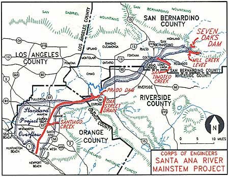
Corps of Engineers Santa Ana River Mainstem Project Map

SARP History

The Orange County Flood Control District (OCFCD) was formed by the State Legislature in 1927.

The Federal Flood Control Act of 1936 authorized a flood control project to protect metropolitan Orange County that included the construction of Prado Dam.  Major floods in Orange County in 1937 and 1938 prompted Congress to direct the U.S. Army Corps of Engineers (Corps) to proceed with design and construction of the dam, which was subsequently completed in 1941.

In 1962, the OCFCD asked the Corps to review the federal flood control work authorized by the 1936 Federal Flood Control Act. The restudy was approved in 1964, and was completed in 1975 by the Corps LA District Office. During that period of study, it was concluded that the existing Prado Dam and Santa Ana River improvements only provided a 70-year level of flood protection. The report recommended an “All River Plan” alternative (later renamed the Santa Ana River Mainstem) that included:

  1. a large flood storage reservoir in San Bernardino County (that became Seven Oaks Dam),

  2. the raising of Prado Dam (to increase flood storage capacity) and improvement of its outlet works, and

  3. reconstruction of the lower Santa Ana River Channel to increase its capacity.

The goal of the 1975 study was to develop a plan to address the “Standard Project Flood”, one that has about a ½ percent chance of occurring any given year, or that statistically tends to occur about once every 200 years. 

The Corps was authorized by Congress in the Water Resources Development Act of 1976 to undertake the Phase 1 General Design Memorandum (GDM) for the project, which was completed in 1980. In 1986, the Phase 2 GDM (a more detailed study) was completed and submitted to Congress, requesting authorization for a “new construction start”.  The project was authorized for construction in 1988, and the three Local Sponsors (Flood Districts of Orange, Riverside and San Bernardino Counties) signed a Local Cooperation Agreement (LCA) with the Corps in 1989. The LCA defined the roles and responsibilities for the project among the four parties. Construction began in 1989 with improvements to the Lower River near the Pacific Ocean.

Over the ensuing 28 years, much of the construction work has been completed but a number of key elements remain.

As of 2017, Seven Oaks Dam has been completed and turned over to the Local Sponsors for operation and maintenance.  Approximately 95% of the reconstruction work in the lower river channel has been completed with remaining work consisting of bank protection improvements in the Yorba Linda area (under construction), and strengthening of the bridge piers supporting the BNSF Railroad in Corona. The Prado Dam embankment has been raised and the outlet works have been reconstructed to convey discharges of up to 30,000cfs. Additional lands for the expansion of the Prado reservoir still need to be acquired, several protective dikes in the Prado basin remain to be built and the spillway for Prado Dam has yet to be raised.  It is anticipated that the project may be completed in 2021, pending Federal appropriations.

Links in this section relate to Body

Share This

  • Share this page to Facebook
  • Share this page to Twitter
  • Share this page to Linkedin
  • Copy this page as a Link

Content block block-customjs

Body
Orange County Government Logo -- OC Home

County Directory Assistance

855.886.5400

Navigation

  • Project Maps
  • 7-Year Capital Improvement Program
  • Open Bids

Quick Links

  • Acceptable Use
  • Accessibility
  • Contact the County
  • Disclaimer
  • Sitemap

Resources

  • Public Meetings & Agendas
  • Public Records Request
  • Email Subscriptions
  • myOCeServices
  • APWA
  • Privacy Policy

Follow Us

  • Connect on Facebook
  • Connect on Twitter
  • Connect on Youtube
  • Connect with RSS
  • Connect on Chat
  • Connect on Flickr
  • Connect on Apple
  • Connect on Google

The OCTM

Making Orange County a safe, healthy, and fulfilling place to live, work, and play, today and for generations to come, by providing outstanding, cost-effective regional public services.

Browser Support Notice

This browser is no longer supported and some key features will not work. We strongly recommend using Edge, Chrome 70+, Safari 5.x+ and Firefox 5.x+.

Tuyên bố miễn trừ trách nhiệm

Để tạo sự tiện lợi cho người dùng, trang web của Quận Cam này sử dụng dịch vụ dịch ngôn ngữ miễn phí của Google. Khi nhấp vào nút "Tiếp theo", quý vị hiểu rằng các trang của trang web này sẽ được chuyển sang những ngôn ngữ khác ngoài tiếng Anh. Quận Cam đã cố gắng hết sức để bảo đảm tính chính xác của bản dịch. Tuy nhiên, không có vi tính hóa hay bản dịch tự động nào là hoàn hảo. Ví dụ, máy không hiểu được ngữ cảnh nên không thể diễn đạt trọn vẹn ý nghĩa của văn bản. Ngoài ra, có thể thấy sự khác biệt liên quan đến tiếng địa phương hay sở thích vùng miền. Bên cạnh đó, những hình ảnh có chữ, các tập tin PDF, và các ứng dụng đặc biệt trên trang web này cũng không thể được dịch. Quận Cam không chịu trách nhiệm về các bản dịch do Google cung cấp. Phiên bản gốc của trang web này là bằng tiếng Anh. Trong trường hợp có sự khác biệt giữa bản tiếng Anh của trang web và bản dịch, bản tiếng Anh sẽ được ưu tiên. Khi nhấp vào "Tiếp theo", quý vị hiểu rằng bất kỳ sự khác biệt hoặc bất đồng nào trong bản dịch đều không mang tính ràng buộc và không có hiệu lực pháp lý. Quận Cam không thể bảo đảm tính chính xác của văn bản đã chuyển đổi và không chịu bất kỳ trách nhiệm nào phát sinh từ việc quý vị sử dụng hoặc dựa vào bản dịch do Google cung cấp.

Descargo de responsabilidad

Para la comodidad de los usuarios, este sitio web del Condado de Orange utiliza el servicio gratuito de traducción de idiomas de Google. Al hacer clic en el botón "Siguiente", usted entiende que las páginas de este sitio web se convierten en un idioma distinto del inglés. El Condado de Orange ha hecho todo lo posible para garantizar la exactitud de la traducción. Sin embargo, no existe informatización ni traducción automática perfecta. Por ejemplo, la traducción no tiene en cuenta el contexto y el sistema no puede traducir el significado completo del texto. Además, puede encontrar diferencias relacionadas con los dialectos o preferencias regionales. Tampoco puede traducir gráficos con texto, archivos PDF y aplicaciones especiales en este sitio web. El Condado de Orange no es responsable de la traducción proporcionada por Google. La versión original de este sitio web está disponible en inglés. Si hay alguna discrepancia entre la versión en inglés de este sitio web y la versión traducida, prevalecerá la versión en inglés. Al hacer clic en "Siguiente", entiende que cualquier discrepancia o diferencia en la traducción no es vinculante y no tiene ningún efecto legal. El Condado de Orange no puede garantizar la exactitud del texto convertido y no asume ninguna responsabilidad que pueda derivarse de su uso o confianza en la traducción proporcionada por Google.

면책 조항

사용자의 편의를 위해, 본 오렌지 카운티 웹사이트는 무료 Google 언어 번역 서비스를 사용합니다. "Next"(다음) 버튼을 클릭하면, 본 웹사이트의 페이지가 영어 이외의 언어로 제공됨을 이해하는 것으로 간주됩니다. 오렌지 카운티는 번역의 정확성을 보장하기 위해 모든 노력을 기울였습니다. 그러나, 완벽한 전산화 또는 자동 번역은 없습니다. 예를 들어, 번역은 문맥을 고려하지 않기 때문에 텍스트의 의미를 온전히 번역할 수 없습니다. 또한, 지역 방언 또는 선호도와 관련된 차이점도 발견할 수 있습니다. 또한, 본 웹사이트에서는 텍스트가 포함된 그래픽, PDF 파일, 특수 애플리케이션은 번역할 수 없습니다. 오렌지 카운티는 Google에서 제공하는 번역에 대해 책임을 지지 않습니다. 본 웹사이트의 원래 버전은 영어로 제공됩니다. 본 웹사이트의 영어 버전과 번역 버전 사이에 불일치가 있는 경우 영어 버전이 우선합니다. "Next"(다음)를 클릭하면, 번역의 불일치 또는 불충분한 내용은 구속력이 없으며 법적 효력이 없음을 이해하는 것으로 간주됩니다. 오렌지 카운티는 변환된 텍스트의 정확성을 보장할 수 없으며, 사용자가 Google에서 제공하는 번역을 사용하거나 의존함으로써 발생할 수 있는 어떠한 책임도 지지 않습니다.

免責聲明

為方便使用者使用,本橙縣網站採用了 Google (谷歌) 免費語言翻譯服務。當您點擊「Next」(下一個)按鈕,即表示您了解本網站內容將自動翻譯為非英文語言。橙縣已盡力確保翻譯內容的準確性,但機器或自動翻譯服務無法達到完美。例如,翻譯無法完整呈現語境含義,亦可能無法精確反映原文內容。此外,您可能會發現因地區方言或用語偏好而有所差異。而且,本網站上的圖像文字、PDF 檔案以及特定應用程式內容亦無法透過此翻譯服務轉換。橙縣對 Google (谷歌) 翻譯所提供的翻譯內容不負任何責任。本網站的原始語言版本為英文。如英文版本與翻譯版本內容有任何不一致之處,應以英文版本為準。當您點擊「Next」(下一個)時,即表示您了解翻譯內容若有任何差異或不一致之處,均不具法律效力,且不具任何約束力。橙縣無法保證翻譯內容的準確性,亦不對因您使用或依賴 Google (谷歌) 翻譯結果而產生的任何後果承擔責任。

سلب مسئولیت

برای راحتی کاربران، وب‌ سایت اورنج کانتی از سرویس ترجمه رایگان گوگل استفاده می‌ کند. با کلیک روی دکمه "بعدی"، شما تأیید می‌کنید که محتوای این وب ‌سایت به زبان‌هایی غیر از انگلیسی ترجمه خواهد شد. اورنج کانتی تمام تلاش خود را برای دقت ترجمه‌ها انجام داده است، اما هیچ سامانه ترجمه ماشینی بدون خطا نیست. به عنوان مثال، این ترجمه‌ها معمولاً به زمینه‌ی متن حساس نیستند و ممکن است نتوانند معنا و مفهوم دقیق را به‌طور کامل منتقل کنند. همچنین ممکن است تفاوت‌هایی ناشی از لهجه‌ها یا ترجیحات منطقه‌ای مشاهده شود. علاوه بر این، امکان ترجمه گرافیک‌های حاوی متن، فایل‌های PDF و برخی برنامه‌های خاص در این وب‌سایت وجود ندارد. اورنج کانتی مسئول ترجمه‌ای که توسط گوگل ارائه می‌شود، نیست. نسخه اصلی این وب‌ سایت به زبان انگلیسی در دسترس است. در صورت وجود هرگونه اختلاف یا مغایرت بین نسخه انگلیسی و نسخه ترجمه‌ شده، نسخه انگلیسی معتبر و ملاک خواهد بود. با کلیک بر روی "بعدی" ، شما تأیید می‌کنید که هرگونه اختلاف یا مغایرت در ترجمه، الزام‌آور نبوده و هیچ‌گونه اثر قانونی ندارد. اورنج کانتی نمی‌ تواند دقت ترجمه ارائه ‌شده توسط گوگل را تضمین کند و هیچ‌ گونه مسئولیتی در قبال استفاده یا استناد شما به این ترجمه را بر عهده نمی‌ گیرد.

إخلاء المسؤولية

لراحة المستخدمين، يستخدم هذا الموقع الإلكتروني التابع لمقاطعة أورانج خدمة الترجمة المجانية من Google. من خلال النقر على زر "التالي"، فإنك تقر بأن صفحات هذا الموقع سيتم عرضها بلغات غير اللغة الإنجليزية. لقد بذلت مقاطعة أورانج أقصى جهد ممكن لضمان دقة الترجمة، إلا أن الترجمة الآلية لا يمكن أن تكون دقيقة بشكل كامل دائمًا. على سبيل المثال، لا تراعي الترجمة الآلية السياق، وقد لا تتمكن من نقل المعنى الكامل للنص الأصلي. بالإضافة إلى ذلك، قد تلاحظ وجود اختلافات تتعلق باللهجات أو التفضيلات الإقليمية. كما أن الترجمة لا تشمل الصور التي تحتوي على نصوص، أو ملفات PDF، أو التطبيقات الخاصة الموجودة على هذا الموقع. لا تتحمل مقاطعة أورانج أي مسؤولية عن الترجمة التي توفرها خدمة Google. النسخة الأصلية من هذا الموقع متاحة باللغة الإنجليزية. وفي حال وجود أي تعارض أو اختلاف بين النسخة الإنجليزية والنسخة المترجمة، تُعتَمد النسخة الإنجليزية. من خلال النقر على "التالي"، فإنك تقر بأن أي تعارض أو اختلاف في الترجمة غير مُلزِم ولا يترتب عليه أي أثر قانوني. ولا تضمن مقاطعة أورانج دقة النص المُترجَم، ولا تتحمل أي مسؤولية قد تنشأ عن استخدامك أو اعتمادك على الترجمة المقدمة من Google.