

Content block block-1384680264-1789531325
Where is the Santa Ana River Canyon Habitat Area?
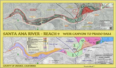
The Santa Ana River Canyon Habitat Area is comprised of approximately 1,100 acres of canyon habitat along the Santa Ana River from downstream of Prado Dam to Weir Canyon Road.
What is the Habitat Management Plan?
The Santa Ana River Canyon Habitat Management Plan (HMP) was developed in 2009 as a requirement of the Santa Ana River Mainstem Project (SARMP). The HMP addresses mitigation of impacts on the floodplain and open space wildlife habitat in the Santa Ana Canyon downstream of Prado Dam.
The HMP includes:
• Preservation and maintenance of the existing habitat at the time of plan adoption
• Recommendations for future habitat enhancement, and;
• Protection of recreational components within the Habitat Management Area (HMA)
The primary objectives of the HMP are to:
1. Develop a plan for the management of floodplain habitat to be reserved as open space.
This is in accordance with the requirements of the Local Cooperation Agreement (LCA) between the US Army Corps of Engineers and the SARMP local sponsors, which include the Orange County Flood Control District (OCFCD), Riverside County Flood Control and Water Conservation District, and San Bernardino County Flood Control District.
2. Identify the HMA and its resources as required by the SARP Phase II General Design Memorandum Final Supplemental Environmental Impact Statement (FSEIS) and the Local Cooperation Agreement (LCA).
3. Identify various activities permitted within the HMA.
4. Identify maintenance standards and responsibilities, and;
5. Identify existing uses within the floodplain and any operational constraints posed by existing uses.
Former Citrus Orchard within the HMA
In 1987, the Orange County Flood Control District (OCFCD), as part of a 240-acre purchase from land developer CW Associates, acquired a 21-acre citrus orchard, located along the Santa Ana River floodplain in the city of Yorba Linda within the HMA. The area remains under the ownership of the OCFCD for flood control purposes.
In 2024, the California Department of Food and Agriculture (CDFA) confirmed the presence of Huanglongbing (HLB)-positive trees within the orchard. The infected trees were designated a public nuisance and the CDFA issued an order to treat and remove the infected trees.
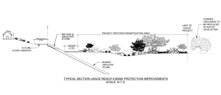
The former citrus orchard will be restored to conditions supporting native habitat. The existing habitat adjacent to the orchard currently supports the least Bell’s vireo, a federal and state endangered bird species. The US Fish and Wildlife Service (USFWS) and the California Department of Fish and Wildlife (CDFW) support efforts to remove man-altered habitats in favor of expanding native habitats within the HMA, with USFWS actively encouraging a land use change of the former orchard to restore habitat suitable for the least Bell’s vireo.
Santa Ana River Parkway Project within HMA
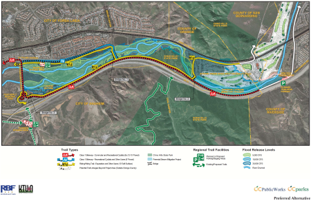
The County of Orange is proposing to extend and realign the Santa Ana River Bikeway and Riding and Hiking Trail to better serve users and to complete its portion of the proposed 100-mile recreational parkway adjacent to the Santa Ana River. The project site is located along the Santa Ana River Parkway between Gypsum Canyon Road and the Orange County Boundary.
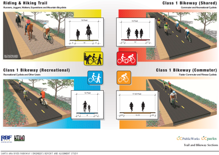
• The Santa Ana River Parkway Project will extend the Santa Ana River Bikeway and the separate Santa Ana River Riding and Hiking Trail within this parkway.
• The Santa Ana River Bikeway is a regional Class I (off-road, paved) bikeway; it accommodates pedestrians and commuter and recreational bicyclists.
• The Santa Ana River Trail is a regional riding and hiking trail (unpaved); it accommodates walkers, hikers, runners, joggers, mountain bicyclists, and equestrians.
Currently the Orange County portion of the Santa Ana River Class I Bikeway extends 28 miles from the Pacific Ocean to the county boundary. The bikeway is adjacent to the Santa Ana River for most of this distance. The 26-mile Riding and Hiking Trail also begins near the Pacific Ocean and ends approximately 2 miles downstream of the Orange County boundary, at Gypsum Canyon Road in the city of Yorba Linda. Access to the Parkway is available from numerous public roadways which span the river, and from regional and local parks and trails.
Flood Control Improvements within the HMA
Flood control improvements within Santa Ana River between Prado Dam and Weir Canyon Road (known as Reach 9) include levee projects (Phase 1, 2A, 2B, 3, 4, 5A, 5B, BNSF, Mobile Home, BNSF) for the protection of the:
- SR-91 Freeway
- Green River Housing Estates
- Green River Mobile Home Park
- Green River Golf Course
- Residential and commercial establishments along La Palma Ave in the city of Yorba Linda and;
- Santa Ana River Interceptor (SARI) Line – a major sewer trunk line owned and operated by the Orange County Sanitation District and Santa Ana Watershed Project Authority.
Restoration, mitigation and conservation efforts for the Reach 9 improvements are included in the HMP and include native vegetation establishment.